Wednesday, June 13, 2012

We are currently right in the middle of Washington State (well, more or less).  This afternoon we visited the Aplets and Cotlets factory in Cashmere, a sleepy little town that is 'famous' (ha!) for this little candy reminiscent of Turkish Delights.  

Let's see, last time we updated we were in Bend, OR.  I (Daisy) really liked this town, and would have loved to spend more time there.  Alas, Canada called and we headed North once again.  About 20 miles from town we stopped for dinner at a Safeway.  We had carried a ton of food, but in the middle of what seemed like endless headwinds, we decided to get the "Shanghai Tonight" special for $9.99, and remarkably it was more food than we could eat.  Ha!  While we were eating a woman offered us a ride and a camping spot in her yard.  She wanted to help us out since her son is plotting a South American bike tour.  We told her that we wanted to keep riding, but thanked her and wished her son luck.  

We ended up stopping that night at the best wild camping spot we've found yet.  There was a beautiful overlook next to the road that included a pedestrian bridge across a 300' river canyon.  Just on the other side of the bridge there was nothing but flat, sandy ground with shrubs and trees.  Taking shelter from the wind behind the trees, we were happy campers on the soft ground.

The next day was characterized by one thing:  HEADWIND.  we fought the headwind all day long.  The internet set that the wind was 20 to 25 mph, but by the end of the day it felt worse.  Eastern Oregon was beautiful, and we could see the mountains still getting snowed on, but it was really hard to fight the headwind.  At certain moments we were really discouraged, but luckily we had a fantastic diversion cheer us up:  at a rest next to the road a herd of donkeys approached and we fed them all of the carrots that were going bad in our food bag.  What fun!  

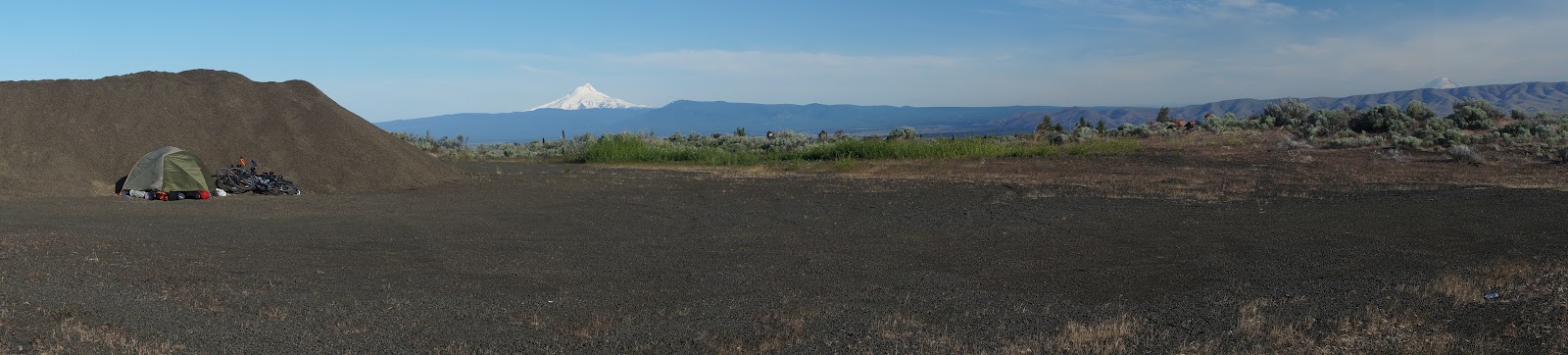
We called it quits early that night, and camped in the only place around that gave us any kind of shelter from the wind:  a giant pile of gravel.  I dug out a spot right up close and we settled in for the night.  The rain fly flapped until the morning. 

On Sunday we crossed the river into Washington.  Yippee!  I was so excited to be back in my home state.  Actually, I still am.  Even better, my parents met us in a state park next to the Columbia and are now following along with us.  During the day they slowly drive along and explore and we ride, then we meet them in a predetermined campground for the night.  My mom makes the best dinners!  It is wonderful to be greeted in camp by the screaming family dog and a lovely salad. 

Because of this luxury, we've been riding long days.  Monday was just over 100 miles through the flat and mostly featureless "Horse Heaven Viticultural Area".  Apparently the Columbia River has been siphoned off to feed grapes in what would otherwise be scrublands.  The road was in the middle of nowhere, and we almost despaired of making it back to civilization.  Little did we know that we had been gradually climbing up over 1,000'.  We thought it was flat!  And then we descended...

Yesterday, too, we road over 90 miles.  We rode through busy Yakima, stopping for ice cream, and finally got back on the Adventure Cycling route.  Yay!  We were happy to be on pretty roads again.  We spent 25 miles in a beautiful river canyon, and then emerged into the valley at Ellensburg.  The valley... and the headwind.  It was terrible.  Especially Jason, who is built like a sail to catch the wind, was suffering.  We persevered though, and made it into the mountains.  After a wonderful night with my parents in the pines, we finished a gentle Blewett Pass this morning and descended all the way to Cashmere.  If all goes well we will be on the West side of the mountains on Friday night, and in Bellingham in time to see the Farmer's Market on Saturday.  I'm soooo excited!  
 
PS - The computer I'm using won't let me arrange the pictures artfully... you'll just have to pretend!  
Feeding the donkeys!

Daisy's home state!

The Crooked River Canyon north of Bend.  Best wild camping ever!

Shelter from the wind provided by... a gravel pile!

Jason can be protective of his (many) munchies

Family Reunion!  (Except for my sister)

I love Citrus!!

Friday, June 8, 2012

Eastern Oregon

Eastern Oregon is cooler than we thought. OK, so Daisy already thinks Oregon is a really awesome state, but now the impression has improved further. We are in the library in Bend, OR, and today has been absolutely awesome so far!

Ice in the lava tube cave.
We woke to ice on our tent - it was a bit cold overnight - but no snow. We were wild camping across the street from an RV park. Ha. We biked a few miles (~10) up the road and found a lava tube cave! We arrived right as it opened for the day, so we had the cave to ourselves. (A mile long and at times 30' high.) As we were leaving two school buses full of children arrived... We continued northward and arrived at the city of Bend. As we entered downtown, we asked a random buy-on-a-bike what his recommendation was for lunch. After a few choices, we decided on Brother Jon's, a brew-pub (Deschutes Brewery). It was "sort of" on his way home, so he decided to ride us there. He was getting ahead of us a little, but then noticed that we were a little slower after we carefully went off a curb, instead of jumping into the street. The food was great, definitely filled us up.


Snowy morning... before additional snow.
So, you may be asking, why are we in Eastern Oregon? It is true that the ACA (Adventure Cycling Association) Sierra-Cascades route drops into Bend, and a few other towns on the east side of the mountains, but we have been off route for a few days. It started a few days ago when we woke up to snow on our tent, the ground, and in the trees. (It was only ~1 inch of accumulation, but it did make the trees look beautiful.) After about 8 miles, the snow storm was going quite well. Visibility was low, it was starting to stick to the roads, (we were really cold and wet,) and we decided that it might be better to head east out of the storm. (By the way, we had talked to Daisy's father the night before, who told us that there was a week-long storm coming -- low pressure [rain] all the way to Japan.) After about a mile on Rt 140 in the snow, we pulled off. It just so happened that there was a forest service guy there with an empty pick-up truck heading east! Perfect!! He gave us a ride downhill out of the mountains to Klamath Falls. In case you're keeping track, our score is two for two on hitching rides out of snowstorms.

Treating ourselves to dinner while planning a new route,
hopefully free of snowstorms.

We got stocked up at the grocery store and headed north. Unfortunately, the shortest route also happened to be heavy with trucks (Rt. 97). The shoulder narrowed, and then the road was sandwiched between a lake and a hill with a concrete barrier. We decided not to risk our lives further and head back to town to regroup. We ended up staying at a funny, "old school" hotel (it actually had real keys!) and working out a new route.


The next morning we headed east. We got into the rural part of Oregon quickly. And then we left it and entered nowhere-land. This nowhere-land happened to be along forest roads 30 and 28 between the small towns of Beatty and Silver Lake. To give you an idea, that afternoon and the next morning we saw about 10 vehicles - and four were forest service trucks. We did see a lot of trees. Thick patches as well as the "thinned" logged areas. That night we made dinner near a stream and I think I saw the most mosquitos I've ever encountered (more than Alaska). The lemon-eucalyptus bug spray worked well (no bites) but it didn't stop them from swarming.

Cooking dinner at city hall.


I enjoyed the break from traffic, but it was also nice to get back to "civilization" for a change. Our use of public spaces continues - yesterday for lunch we cooked outside the post office, and last night for dinner we cooked under an awning at the city hall building in La Pine while a windy storm rolled in.


Clouds dumping precip. on the Cascades.

When we came back in sight of the Cascade range, we could see the clouds dumping rain/snow/whatever in the mountains. (This made us feel a little more justified for leaving the route.) Earlier we were told that snow was falling down to 4500' elevation (we're at 3500' now). Our current plan is to keep heading north on the east side of the range and reconnect with the ACA route in Washington. We'll finish it to Bellingham, and catch the border, too.

On a related bike-maintenance side note, my chain has been used for almost 1900 miles of touring and is showing little sign of stretching (<0.75)!! Wow! (Usually they get replaced at 1000+ miles. I guess I've been using the 'granny gear' a lot instead of cranking up those mountains.) Today I had my rear tire trued a little, but other than that no maintenance has been necessary - that check-up at Freeze-Thaw Cycles before leaving was very effective. (Daisy did get her chain replaced and rear tire trued back in Tahoe.)


After journal-writing I always give dramatic readings to Daisy, who suggests edits.
 
Time to continue northward to the OR-WA border. Daisy's parents will be meeting us in a couple days and camping with us for the Washington section. (And Citrus the German Shepard, too!)

Welcome back to "civilization"!

From Northern California to Southern Oregon

A shot of some epic clouds - we've finally been seeing lots of them since we
left California!
We've been a bit isolated for the past week, so we've got a bit of catching up to do here on the blog.  It's my (Daisy) job to write about our on route adventures from Tahoe City, CA to Ashland, OR.  My, there is a lot to say.

For the entire week between these two places we were booking it - I think that our 'slowest' day was 68 miles, and our longest was 96.  Yikes!  After the numerous and epic mountain passes of Southern and Central California, this northern stretch was relatively mild.  We saw sooo many pine trees!  The national forests seemed to go on forever, but luckily the logging traffic was not too bad.  

There was one final big pass in California that we were really looking forward to in Lassen Volcanic National Park.  Our story of this pass is really quite a tale...

A distant view of the volcanic Mt. Lassen
We planned to ride to the base of the pass on Thursday, and then do the climb and descend on Friday.  The ride to the base was very nice, curving around a rather large Lake Almanor.  We even got to ride along a curvy bike path for quite a while right next to the water.  At the end of the road around the lake we turned to head towards the park... only to see the sign on the road declaring that the pass was still closed due to an extreme accumulation of snow and ice.  No!!  We immediately called my father to do the online detective work to make sure the sign was right.  He confirmed it.  We called the park information line.  It was after hours, so we just got the recorded message saying that the pass was closed and that it was to open sometime in the next week.  Great.  We wanted to call again in the morning, so we decided to camp nearby and try again.  We found a spot in what turned out to be the towns flood control canals, whoops!  No rain though, so we were fine until morning.

Riding in the flats.
In the morning we woke up and rode to a nearby town, Chester, where we got coffee and a cinnamon roll and checked the website.  The picture on the website showed multiple miles of unplowed road, and the message on the information line was the same.  We were sad, but decided to take the road around the park and continue north.  The new route was nice - flat and fast and nearly traffic-free.  The miles flew by, and before we knew it we were around the mountain and back on the route.  Before descending to the route though, we stopped at a beautiful overlook that gave us clear views of both Mt. Lassen and Mt. Shasta, two huge volcanic peaks that dominated the skylines in either directions.

At the intersection with the original route we turned to go buy chips in town and saw... a road sign saying that the pass was OPEN.  Ack!!!  Apparently they hadn't updated the message or the website, and had opened it that afternoon.  I had a little meltdown on the side of the road, and then we pulled it together and bought some ice cream as a (pathetic) consolation prize.  There was also a 'book swap' where we traded in a few of our already-read books for some new ones.  We limped on down the road for another 30ish miles,  trading extra miles for the disappointment of a missed pass.  Luckily, a wonderful surprise was waiting for us at the State Park where we were planning on staying.
Our wonderful bike touring friends in Burney Falls State Park.

The surprise was not a nice view of a waterfall, or a pleasant hiker-biker site (although both of those things were there too), it was another pair of touring cyclists!  We got to share a site and some wonderful conversation with Eric and Sophia, a Swedish couple who decided to leave their modern lives behind for a year to ride their bicycles and get a new perspective.  They were fantastic - friendly and funny and full of just the kind of cycling stories that kept us chatting into the night.  We talked about all the crazy things that happen on bike tour - it's like a special language that only people who've done it can decipher.  For example, how luxurious a picnic table can be.  The real kicker though... they had come over the pass denied to us - a whole day before it had been opened to cars!  They got a tip from a local; tour guide about sneaking past the barricades.  The video they showed us looked epic - the snow was piled at least 5' high next to the road, like they were riding through a canyon of snow.  We had such a good time talking to them though that we were ok with missing the pass.  If we had ridden it, we may never have met them!
Closed... to cars...

We continued riding north towards Oregon, into rather isolated countryside.  Finally we actually ran out of side roads and had to ride (uphill) on I-5 for 8 miles across the California - Oregon border.  For you East Coasters, I-5 is the border to border massive freeway of the West Coast.  Lots of trucks, not much fun for bikes.  Yet, we had no choice, so we did it.  We left the freeway at Oregon Exit 1.  Yay for riding across the entire state of California!  We had one more big hill to climb until descending into Ashland.  On the descent the road was closed, but emboldened by Eric and Sophias story of Lassen, we continued on.  We found that the road had been washed out by a landslide, but it was easy to walk the bikes across and snap a few pictures with the machinery parked there for cleanup.

Mt. Shasta!  Huge!
Ashland was a funny little artist's town, known for it's Shakespeare Festival, which actually runs for 8 months of the year.  Ha!  We got a room in a funny little hostel run by an artist couple.  The woman was horrified that I didn't know the name of some (apparently very famous) poet.  I should have asked her if she knew of any famous statisticians... I bet she would have not even known Gauss.  Oh well, different worlds I guess.  We met some very kind people at the local Co-op, and one man suggested a tasty Thai place for dinner.  We went there and, hungry as all get-out, ordered three entrees.  They were all delicious!  Most incredibly, another couple at the restaurant was so inspired by our bike tour that they paid for most of dinner, without even telling us! Thank you to those nameless folks, we will someday pass on the favor.

We slept in an elementary school play yard with this excellent map painted on the ground.
They were kind enough to have painted in only the states we were riding across!

Daisy is tired and cold!  Time to REST!
The next morning we climbed a pass heading north, but only 30 miles into the day I was exhausted.  We found a campground with only 6 sites that was closed, and we stopped to read for a bit.  When it started to rain we decided to stay the night and rest.  Good thing too - the rain refused to stop.  It was so insistent that when it came time to make dinner we ended up cooking in the vault toilet stall, as it was the only dry place.  After a quick call to my dad, who informed me that there was nothing but rain for the next 10 days, we fell asleep to the insistent sound of raindrops.  This is the part of the story that Jason (next to me at the library in Bend) is typing even now...

Wednesday, May 30, 2012

Yosemite and beyond


Finally, some home-grown eggs! 
Today we are in Lake Tahoe getting our bikes checked.  The library is closed so we are in a coffee shop with wifi, using my tiny iPod touch to access the web. It's surprisingly easy!

Since we last updated, a lot has happened. We made it to Yosemite national Park, narrowly missed a visit with a dear friend of Daisy's, climbed two passes in one day, and showered twice! We didn't know it at the time, but at the coffee shak where we wrote last we were mere miles from the geographic center of the state of California. Wow!  Also in that little town we bought some delicious home grown eggs from the feed store.  I had been dreaming of eggs for a long time and we proceeded to make fried egg and cheese burritos for lunch next to a beautiful lake.

Snow!
That same day we saw the first non-sunny weather of the trip.  A lot of it, too!  We triumphantly rode into Yosemite Park only to find that a storm was rolling in, and strong.  To get into the park we had to climb over two big hills of 2,000' each.  We got rained and hailed on during the first climb, and during the second... The snow really set in.  We were going really really fast to stay warm in the face of all that white, but about half a mile from the summit the visibility was terrible and the snow was starting to accumulate.  In the face of these actually dangerous conditions we decided to hitch a ride.  Actually, two since we had so much gear we needed two cars.  Jason got a ride with some recent college graduates, and I got a ride with a great couple from Maine.  They were super nice, especially when I left my soggy gloves in their car and had to track them down in a massive campground!

Yosemite was, as expected, spectacular.  We spent a full day there, during which it proceeded to rain all day long.  We were warm and dry in the visitors center and shuttle bus, happy as little clams to be resting. We ate an entire large pizza for a late lunch, and were so full that we only had bananas and gummy bears for dinner. Hee hee.
Reflections along Tioga Pass

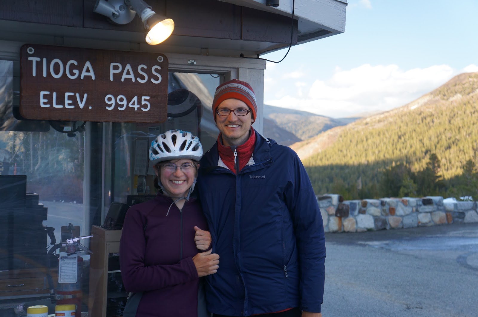
We climbed out of Yosemite valley over Tioga Pass - the highest pass of the trip at 9,945'. It was incredible! The ride to the top took all day, and was at times very cold, but the views were utterly spectacular.  There were high meadows, steep mountains, and plenty of snow on the ground.  We were suitably exhausted at the top.  Exhausted, but also in awe.  Yosemite is another place we'll have to come back to.

We made it!  Highest spot on the route!
Yesterday we rode over both Monitor and Luther Passes.  Monitor pass was remarkable because it was 3,000' up the same hillside.  We just crisscroased it, climbing, repeatedly.  But we made it!  In a little town on the other side we stopped to buy stamps and met a woman who had been postmaster for 25 years.  She knew everyone and everything in that town.  She shared with us a few stories before we eased back onto the road.  After Luther Pass, which was another 2,000' of steep climbing, we descended into Lake Tahoe.  This lake is huge!

We were exhausted last night, and were happy to get a hiker biker site in a state park.  Today we will enter Truckee, and complete the second of our five map sections.  We are really getting into a groove and the mileages are really started to pile up.  We might still make it all the way to Canada!  We only have a few more truly epic(7,000'+) passes left.  Also, we're getting much faster at climbing!   
A Panoramic shot of a lake near the top of Tioga Pass (Burr!!)

Friday, May 25, 2012

Slim's Koffee Shop!

Yes, that's right! Check the photo. Complete with two benches and a fire barrel. Ha! this morning we just climbed a steep (8-9%) 4 mi out of a river area into North Fork. This appears to be a cool little spot.(Note: no blueberry bagels this morning because they were eaten by a 'coon because they were left in a motorcycle sachel last night.) Later today we'll be in Yosemite Valley!

Since we're borrowing the barista's computer, I'll make this quick, and post a few photos. the redwoods were great. the park was high and the climbing tough. However, the 20 mile descent out of King's Canyon NP was perfect - no need for breaks or pedaling. We went out to dinner last night, for a change - a nice big plate of Mexican food. yum. OK, off soon!

[These photos might not have loaded right, so if not, we'll post again later...]
Us near the General Sherman tree

Sunset at Sunset campground
Cattle grates. Saw many!

Stealth campsite last night


This sweet morning spot: Slim's Koffee Shop!

Tuesday, May 22, 2012

First national park today -- Sequoia

After more than a week, we are coming upon our first (of many) National Parks. It is Sequoia National Park, and we're planning (and hoping, ha) to camp inside it tonight. We are so excited to buy our 'annual pass' to the parks!

The past few days have seen many ups and downs... I mean that both figuratively and literally. Last Friday morning, we have a little bit of a 'strugglefest' day. These happen every once in awhile. I (Jason) woke up too early, and we ended up getting started on the wrong foot (pedal?). We were a bit bummed, too, because we realized that we wouldn't get to see any of the Tour of California bike race because our routes diverged. (That is, the Tour was taking a shorter route than we were between the towns!) In any case, by the evening we had things all worked out and were happily staying at a hotel/motel. ha! Our first/only one of the trip!

Saturday saw us cruise across the valley floor and out of the desert before it got too hot. We ascended into one of the most productive areas for wind energy - and saw hundreds of wind turbines! Wow! What a sight. We saw the last of the PCT (Pacific Crest Trail) for awhile, and chatted for a hiker for a few minutes. He had said he biked across the country east-west on both a northern and a southern route, and now he was doing the PCT. We joked that he should do the AT (Appilachian Trail) too, in order to box the country, and he mentioned that he already had! He seemed like one of the ones that was going to make it through the whole PCT. (We saw many that looked like they wouldn't.)

By the end of Saturday, we had made 82 miles - our longest day yet. We saw some really amazing scenery. (see photos). On Sunday we took a "rest day." It is nice to build in one about once a week to let the muscles recover a bit. Strangely, we decided to do 52 miles (many climbing) on this day, but we still had a relaxing afternoon and evening! We finished Section 5 of the route (we're doing it backwards: 5-4-3-2-1) and ended in a town called Lake Isabella. Although the name sounded promising, unfortunately for us the town itself was a dud. The best part was probably that we got to sleep in the tent with the rain fly off and look up at the stars. (The overnight low was just in the low 50s.)

Our first 'giant' redwood.
On Monday we climbed a massive mountain. (The climb was over 30 miles long.) The further up we went, the more (and bigger) trees we saw. We came across our first grove of large sequoia (redwood) trees. And wow, they are big! (If you have seen them, you might think that is an understatement.) The descent was a never-ending ~5%. It was amazing to watch the ecosystems change right before our eyes: large conifers, a small addition of deciduous, mixed, less conifers, and finally sparse shrubs and back into the hot low country. This morning we hit a low of ~500 ft -- which we haven't seen since we left San Diego! (I thought this was a route through the mountains, so I'm still surprised every time we drop low into the hot, desert-y valleys.)
Grassy desert and/or "cattle country."
Note: sometimes there are trees, too.

We have found the meaning of 'cattle country,' as one sign said it: "Watch out for cattle and enjoy the drive." We saw several large cows at the edge of the road (luckily not crossing) which we silently rode by. One pair of animals we startled, they stood up, huffed, and I was glad to be out of there quickly.

This morning (Tuesday) we hoofed it across some low-lying areas. I think Daisy got some extra bike-touring energy, or got in the groove, or something. (She was setting a fast pace!) We even did a little pacelining. It seems every other day (or so) we need to do some grocery shopping. (Part of this is because we don't want to carry extra weight, the other part is that we eat so much...) Today was no exception. After shopping we proceeded to sit at a table in the shade of a tree and eat lunch. Since we're on bikes, we are constantly looking for little places like this (picnic or other tables preferred!) to stop and eat.

Since we're travelling at a different speed than cars, we also see all sort of things along the road's edge: snakes attempting crossings (and smashed ones), tons of lizards and squirrels scurrying out of the way, and a variety of different shaped ant hills are just a few. Lovely details. ... Of course, we also see the bigger picture, too:


What it feels like to be a week and a half in


A typical breakfast cooking scene on a random porch.
We saw this phrase (a classic in the cycling world) chalked on the road this morning:

"It doesn't get easier... you just get faster."

Lance Armstrong said this in a famous cycling movie, and when I saw this on the road I couldn't keep myself from laughing.  It's so true - whether you're training for a bicycle race or taking a six week bicycle tour.  A week and a half in... we are getting faster.

Cold shirt for Jason!
After a week and a half we are used to the routines of the bicycles and the camps.  We are losing the calluses that we had on our fingers from playing banjo and guitar, and instead we have formed calluses on our palms from holding the handlebars.  We finally know where all our gear is in all nine of our bags! The tan lines have been cemented onto our backs, arms, and legs, and our appetites are positively enormous. 
If you click on this to make it big, you'll
see the ridiculous gasp on my face.


 These pictures  show one of our coping mechanisms for the sometimes extreme (90 +) mid-day temperatures:  We get our shirts wet in whatever water is available.  Rivers full of cold meltwater are the best, even though they make us grimace momentarily from the cold.  Our days usually start around 6:00, and we're on the road around 7:30.  Lunch doesn't happen until between 12:00 and 2:00, and then it's a little rest before we ride again in the afternoon.  Depending on the altitude of course.  If we are higher, and it's cooler, we can continue to ride.  If it's hot...  well we usually end up reading for a bit.
 The scenery has been phenomenal - I am truly a girl of the mountains.  Specifically, the Western mountains.  I think back to all we've seen already and it's awe-inspiring.  We started out at the chaos of the US - Mexico border at Tijuana and rode through San Diego, the hot mountains and valleys of Southern California, the desert valleys and the high pines.  Finally we are reaching Central California, the home of giant trees, cool streams, gold trout.  We are past the metropolis (and rude drivers) of the Los Angeles area. 
We found German Shepherd Puppies!!
The going is good.  We are enjoying ourselves immensely, even we do sometimes have moments of struggle (we call the moments "struggle fests").  Usually when one of us is at the end of the rope the other will step in and make some decisions, take some of the weight, or just dump water over the other one's head.  It helps!

We don't know if we'll make it all the way to Canada in the time allowed, but we've come to terms with it.  If we make it to Oregon we'll be happy. The passes are huge now, and the climbing slows us down.  Every day is epic.  Now, we say things like "it's a little pass, only 3,000' of elevation gain".  Really, we do.

We'll keep updating and sharing, but don't be too sad if a month from now we aren't all the way to Canada.  We'll finish the route someday (after we move back to the West Coast...).  I'm still just dreaming, but I love these mountains!